An electromagnetic health risk analysis and assessment is generally prescribed for every facility that emits electromagnetic waves.
In Italy, e.g. Legislative Decree No. 259 of August 1, 2003, also known as the “Code of Electronic Communications,” and its subsequent amendments and additions, in art.87 prescribes that in the case of installation or modification of telecommunications radioelectric plant “the application (…) must be accompanied by documentation to prove compliance with the exposure limits, attention values and quality objectives, relating to electromagnetic emissions, referred to in Law No. 36 of February 22, 2001, and its implementing measures.“
This document, usually referred to as the Electromagnetic Impact Analysis (or EIA) or Electromagnetic Risk Assessment, is therefore a technical document that the telecommunications operator must mandatorily send to Agencies for the Protection of the Environment or Healt of territorial competence, according to the different laws of the country where the technological facility is located.
The electromagnetic risk assessment must be carried out according to the relevant technical standards and taking into account the facility’s radio data as well as the geographical context.
Structural and dimensional characteristics include the elevation of the ground above sea level, the elevation of the installation, the elevation of the radiating elements, the directions of antenna pointing, the dimensions of the antennas, the geometry of the antennas in the case of near-field simulation, and the angle of inclination from the vertical (tilt), if any; additional radio characteristics include the power at the antenna connector (or at individual elements), the frequency the radiation patterns of the antennas. In particular, for mobile telephony antennas, it will be necessary to indicate precisely which diagram and which configuration one intends to use since the most widely used antennas today are multiband antennas with the possibility of selecting the angle of inclination (tilt) in a so-called electrical manner; in fact, these antennas have a large number of diagrams that are a function of the frequency, tilt angle and array of elements being used in transmission. The frequency should be chosen from the one closest to the frequency given in concession to the operator under consideration while for the other data these should be clearly indicated in the radio specifications of the installation.
The purpose of electromagnetic risk analyses is to verify whether a facility can be placed in a given context.
The law requires compliance with intensity limits and electromagnetic field caution values that are defined by national legislations for places where the presence of people is expected; it follows that the electromagnetic impact analysis must analyze all possible points in the space where the presence of people is possible. If we approach the problem from a purely theoretical point of view, the repercussions of a new installation can be felt even indefinitely; therefore, it is a matter of defining a boundary in the surroundings of the installation beyond which the effects can be considered negligible.
The identification of the analysis area will also depend on the presence of other facilities that may contribute to the total electromagnetic field, their distance and their type (radio base stations, radio and TV broadcasters, etc.).
Once the space in which to carry out the analysis has been defined, a method for its representation must be identified from the available map data. In principle, it is considered that an accurate representation of the area and its artifacts is one based on an orographic terrain model in which all places with potential presence of people, particularly buildings, are evident.
The electromagnetic field intensity level is given sum of two contributions: the pre-existing level before the activation of a new facility (which is also called the background level) and the level produced by the new facility.
Analyzing the various regional regulations and laws, we may face with a varied situation that can be summarized in the following three possibilities:
1. broadband mode field level measurement at a specified number of points significant for both the location of the future plant and the location of any other plants around the analysis area; typically, points where, based on an initial theoretical calculation or the evaluator’s technical experience, the electromagnetic field values calculated as contributions from the future plant and any existing plants are found to be highest are recognized as significant;
2. field level measurement using narrow-band mode in order to derive a reliable maximum value;
3. calculation of the field level by considering all existing facilities in an area of given size around the location of the future facility.
All methods have their merits and drawbacks; the broadband instrumental approach is the fastest and simplest but cannot consider all situations at all times; moreover, it does not represent a time-invariant datum. However, the variability of the measured data remains small but, in general, the measurement is a snapshot of that instant and cannot be considered an absolute value. The narrow-band instrumental approach is more complex: in some situations it makes it possible, only in the case of mobile phone installations, to derive, through a subsequent calculation, the worst possible situation at the point of measurement; however, this is true only under the condition of knowing some technical data not only for the future installation but also for the pre-existing installations, and even this approach, however, risks not going to consider all the possible criticalities of the analysis environment. The calculation approach is typically a conservative method that tends to overestimate the background level.
Experience has also shown, in some cases, the difficulties for those preparing an electromagnetic risk assessment for a given facility in obtaining technical data for nearby facilities, if pre-existing and not involved in a new permitting process.
On the other hand, with regard to the predictive calculations, the calculation algorithms to be used are those described in local technical standards, e.g. in OItaly theCEI Guides 211-7 and 211-10.
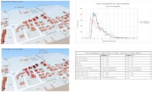
The calculation of the electromagnetic field level will be carried out within the area defined as significant and should be performed at all those points in the space where the presence of people is possible. In absolutely general terms, people can be at all points at ground level and, if in the presence of buildings or artifacts, also at higher elevations. An initial calculation will therefore have to be made at ground level and then at higher elevations until the elevation of the highest building is reached. Since the ground elevation with respect to sea level can vary within the analysis area, sometimes significantly, our firm, thanks to software tools designed and used exclusively, uses calculation methods that follow the orography of the terrain; in this case in a single calculation the field value is represented both at ground elevation and at predefined elevations; furthermore, taking into account the presence of buildings, and assuming that a significant step of elevation increase is chosen, the entire analysis space can be represented by performing a three-dimensional spatial sampling within the buildings. From this analysis, all statistically significant parameters can then be extracted to analyze the scenario, identify The critical points with higher electromagnetic field levels, and possibly compare quantitatively and systematically several different scenarios of plant placement.